Shaded Area Distribution Map for Thrasops batesii
الوصف:
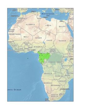
Shaded Area Distribution Map for Thrasops batesii
This is a shaded area map for the species Thrasops batesii from gps coordinate data from Dr. Kate Jackson. Please note that the boundaries are only rough approximations based on vegetation, altitude, and geographic entities (i.e. mountain ranges, streams, etc.).
مشمول على الصفحات التالية:
- Life
- Cellular
- Eukaryota (حقيقيات النوى)
- Opisthokonta
- Metazoa
- Bilateria
- Deuterostomia (ثانويات الفم)
- Chordata (حبليات)
- Vertebrata (فقاريات)
- Gnathostomata (فكيات)
- Osteichthyes (أسماك عظمية)
- Sarcopterygii (لحميات الزعانف)
- Tetrapoda (ذوات الأربع)
- Amniota
- Reptilia (زواحف)
- Diapsida
- Lepidosauromorpha (أشباه العظايا الحرشفية)
- Squamata (حرشفيات)
- Serpentes
- Colubridae (أحناش)
- Rhamnophis
- Rhamnophis batesii
- Lepidosauriformes
- Reptiliomorpha
- Eureptilia
- Neodiapsida
هذه الصورة ليست واردة في أي مجموعات.
معلومات المصدر
- ترخيص
- cc-by-nc
- حقوق النشر
- Kiskaddon, Erin
- مصور
- Kiskaddon, Erin and Chad Trexler
- ناشر
- Kiskaddon, Erin
- مقدم المحتوى
- African Snakes of the Genus Thrasops
- النص الأصلي
- ملف الوسائط الأصلي
- زيارة المصدر
- موقع الشريك
- Thrasops LifeDesk
- ID