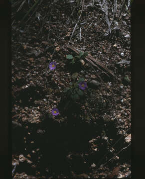
Lagenophora stipitata Girraween National Park Wyberba Queensland 1980s IMG 0045
الوصف:
Summary.mw-parser-output table.commons-file-information-table,.mw-parser-output.fileinfotpl-type-information{border:1px solid #a2a9b1;background-color:#f8f9fa;padding:5px;font-size:95%;border-spacing:2px;box-sizing:border-box;margin:0;width:100%}.mw-parser-output table.commons-file-information-table>tbody>tr,.mw-parser-output.fileinfotpl-type-information>tbody>tr{vertical-align:top}.mw-parser-output table.commons-file-information-table>tbody>tr>td,.mw-parser-output table.commons-file-information-table>tbody>tr>th,.mw-parser-output.fileinfotpl-type-information>tbody>tr>td,.mw-parser-output.fileinfotpl-type-information>tbody>tr>th{padding:4px}.mw-parser-output.fileinfo-paramfield{background:#ccf;text-align:right;padding-right:0.4em;width:15%;font-weight:bold}.mw-parser-output.commons-file-information-table+table.commons-file-information-table,.mw-parser-output.commons-file-information-table+div.commons-file-information-table>table{border-top:0;padding-top:0;margin-top:-8px}@media only screen and (max-width:719px){.mw-parser-output table.commons-file-information-table,.mw-parser-output.commons-file-information-table.fileinfotpl-type-information{border-spacing:0;padding:0;word-break:break-word;width:100%!important}.mw-parser-output.commons-file-information-table>tbody,.mw-parser-output.fileinfotpl-type-information>tbody{display:block}.mw-parser-output.commons-file-information-table>tbody>tr>td,.mw-parser-output.commons-file-information-table>tbody>tr>th,.mw-parser-output.fileinfotpl-type-information>tbody>tr>td,.mw-parser-output.fileinfotpl-type-information>tbody>tr>th{padding:0.2em 0.4em;text-align:left;text-align:start}.mw-parser-output.commons-file-information-table>tbody>tr,.mw-parser-output.fileinfotpl-type-information>tbody>tr{display:flex;flex-direction:column}.mw-parser-output.commons-file-information-table+table.commons-file-information-table,.mw-parser-output.commons-file-information-table+div.commons-file-information-table>table{margin-top:-1px}.mw-parser-output.fileinfo-paramfield{box-sizing:border-box;flex:1 0 100%;width:100%}} Description: English: Girraween National Park is an area of the Granite Belt] in the Darling Downs region of Queensland, Australia reserved as a national park. Girraween is known for its spectacular flowers, dramatic landscapes and unique wildlife. The park is situated 40 km south of Stanthorpe. The southern boundary of the park is the state border between Queensland and New South Wales. It is a twin park with Bald Rock National Park, which lies across the border in New South Wales, and features Bald Rock, the second-largest monolith (after Uluru) on the continent. Curiously, South Bald Rock and West Bald Rock lie in Girraween National Park in Queensland, not in Bald Rock National Park in New South Wales. It features granite landscapes, balancing boulders, clear streams, wetlands, cascades and open forest. The granite outcroppings, such as the Pyramids and Castle Rock at 1112 m, dominate the local scenery. The park contains many kilometres of graded walking trails to the park's major features like the First Pyramid, Second Pyramid, The Sphinx, Turtle Rock, Underground Creek, the Eye of the Needle and Mount Norman - the highest point in the park at 1267 metres. Fire trails can be followed when venturing into the southern and eastern sections of the park. The park has a temperate climate. During winter snow can fall in the area. Date: 7 April 2010, 12:18:54. Source: Own work. Author: John Robert McPherson.
مشمول على الصفحات التالية:
- Life
- Cellular
- Eukaryota (حقيقيات النوى)
- Archaeplastida
- Chloroplastida
- Streptophyta
- Embryophytes
- Tracheophyta
- Spermatophytes (بذريات)
- Angiosperms (ماغنولانية)
- Eudicots
- Superasterids
- Asterids
- Asterales (نجميات)
- Asteraceae (نجمية)
- Lagenophora
- Lagenophora stipitata
هذه الصورة ليست واردة في أي مجموعات.
معلومات المصدر
- ترخيص
- cc-by-sa-3.0
- حقوق النشر
- John Robert McPherson
- المنشئ
- John Robert McPherson
- النص الأصلي
- ملف الوسائط الأصلي
- زيارة المصدر
- موقع الشريك
- Wikimedia Commons
- ID