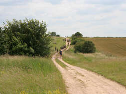
Description: English: Ermine Street near Cranwell. The RAF College is at Cranwell, (see
394632), and the cadets use this route for fitness training. This was the first group of about 30 students that passed me. Another group was following close behind. Ermine Street was one of the three most important Roman Roads. It linked London to York via Lincoln and the River Humber. Several major roads follow its line but between the A1 at Colsterworth and Lincoln it follows the B6403, small country roads and farm tracks (as seen here). This part of its route is also known as High Dyke. See
http://www.channel4.com/history/microsites/B/bigromandig/camesaw/3_49.jsp for a complete description of the route from London to York. Date: 10 July 2007. Source: From
geograph.org.uk. Author:
Kate Jewell. Attribution(
required by the license)Kate Jewell / Ermine Street near Cranwell /
CC BY-SA 2.0. Kate Jewell / Ermine Street near Cranwell. Camera location
53° 02′ 47″ N, 0° 31′ 23″ W View all coordinates using:
OpenStreetMap 53.046500; -0.523000. Object location
53° 02′ 38″ N, 0° 31′ 24″ W View all coordinates using:
OpenStreetMap 53.043990; -0.523300.


