-
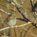
Description: English: A blue waxbill Uraeginthus angolensis at Mlondozi picnic spot, Kruger National Park, South Africa. Date: 9 October 2017, 09:46:53. Source: Own work. Author:
Alandmanson. Camera location
25° 02′ 07.43″ S, 31° 56′ 05.84″ E View all coordinates using:
OpenStreetMap-25.035398; 31.934955.
-
Brindavan River Camp, Zambezi River
-
Brindavan River Camp, Zambezi River
-
CBU campus, Kitwe, Copperbelt
-
Bruce-Miller Farm, Choma, Southern
-
Xanadu Farm, Lusaka
-
Palabana, Chongwe District
-
Hwange, Matabeleland North
-
Chirundu Road, Siavonga, Southern
-
Nsele, Kinshasa
-
Mopani area, Kruger National Park, Limpopo
-
Mahove Tent Camp, Gonarezhou National Park
-
Mjejane Private Game Reserve, Hectorspruit, Mpumalanga
-
Kruger Park, Ehlanzeni, Mpumalanga
-
Hoedspruit
-
City of Matlosana, Southern DC, North West
-
Hoedspruit
-
Hoedspruit
-
Mwekera Forestry College, Kitwe, Copperbelt
-
Mwekera Forestry College, Kitwe, Copperbelt
-
City of Matlosana (near Hartbeesfontein), Southern DC, North West