Myrica pensylvanica range map
Description:
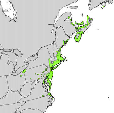
: All biogeographical map images in this gallery could be re-created using vector graphics as SVG files. This has several advantages; see Commons:Media for cleanup for more information. If an SVG form of this image is available, please upload it and afterwards replace this template with {{vector version available|new image name}}..mw-parser-output table.commons-file-information-table,.mw-parser-output.fileinfotpl-type-information{border:1px solid #a2a9b1;background-color:#f8f9fa;padding:5px;font-size:95%;border-spacing:2px;box-sizing:border-box;margin:0;width:100%}.mw-parser-output table.commons-file-information-table>tbody>tr,.mw-parser-output.fileinfotpl-type-information>tbody>tr{vertical-align:top}.mw-parser-output table.commons-file-information-table>tbody>tr>td,.mw-parser-output table.commons-file-information-table>tbody>tr>th,.mw-parser-output.fileinfotpl-type-information>tbody>tr>td,.mw-parser-output.fileinfotpl-type-information>tbody>tr>th{padding:4px}.mw-parser-output.fileinfo-paramfield{background:#ccf;text-align:right;padding-right:0.4em;width:15%;font-weight:bold}.mw-parser-output.commons-file-information-table+table.commons-file-information-table,.mw-parser-output.commons-file-information-table+div.commons-file-information-table>table{border-top:0;padding-top:0;margin-top:-8px}@media only screen and (max-width:719px){.mw-parser-output table.commons-file-information-table,.mw-parser-output.commons-file-information-table.fileinfotpl-type-information{border-spacing:0;padding:0;word-break:break-word;width:100%!important}.mw-parser-output.commons-file-information-table>tbody,.mw-parser-output.fileinfotpl-type-information>tbody{display:block}.mw-parser-output.commons-file-information-table>tbody>tr>td,.mw-parser-output.commons-file-information-table>tbody>tr>th,.mw-parser-output.fileinfotpl-type-information>tbody>tr>td,.mw-parser-output.fileinfotpl-type-information>tbody>tr>th{padding:0.2em 0.4em;text-align:left;text-align:start}.mw-parser-output.commons-file-information-table>tbody>tr,.mw-parser-output.fileinfotpl-type-information>tbody>tr{display:flex;flex-direction:column}.mw-parser-output.commons-file-information-table+table.commons-file-information-table,.mw-parser-output.commons-file-information-table+div.commons-file-information-table>table{margin-top:-1px}.mw-parser-output.fileinfo-paramfield{box-sizing:border-box;flex:1 0 100%;width:100%}} Description: English: Range map of Myrica pensylvanica, now reclassified as Morella pensylvanica — Northern Bayberry. Date: 1999. Source: Digital representation of "Atlas of United States Trees" by Elbert L. Little, Jr. [1]. Author: U.S. Geological Survey. This image contains regular noise, texture, or interference which should be cleaned up using Fourier analysis or some similar appropriate method. Beginning with a higher resolution image may help. čeština ∙ English ∙ français ∙ русский ∙ македонски ∙ português do Brasil ∙ +/−.
Included On The Following Pages:
- Life (creatures)
- Cellular (cellular organisms)
- Eukaryota (eukaryotes)
- Archaeplastida (plants)
- Chloroplastida (green plants)
- Streptophyta
- Embryophytes
- Tracheophyta (ferns)
- Spermatophytes (seed plants)
- Angiosperms (Dicotyledons)
- Eudicots
- Superrosids
- Rosids
- Fagales
- Myricaceae (bayberry family)
- Morella (bayberry)
- Morella pensylvanica (Northern Bayberry)
This image is not featured in any collections.
Source Information
- license
- cc-publicdomain
- creator
- U.S. Geological Survey
- source
- Digital representation of "Atlas of United States Trees" by Elbert L. Little, Jr. [1]
- original
- original media file
- visit source
- partner site
- Wikimedia Commons
- ID