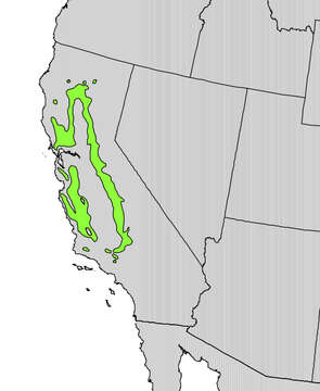
Quercus douglasii range map
Kuvaus:
: All biogeographical map images in this gallery could be re-created using vector graphics as SVG files. This has several advantages; see Commons:Media for cleanup for more information. If an SVG form of this image is available, please upload it and afterwards replace this template with {{vector version available|new image name}}. Description: English: Range map of Quercus douglasii. Date: 1999. Source: Digital representation of "Atlas of United States Trees" by Elbert L. Little, Jr. [1]. Author: U.S. Geological Survey. This image contains regular noise, texture, or interference which should be cleaned up using Fourier analysis or some similar appropriate method. Beginning with a higher resolution image may help. čeština ∙ English ∙ français ∙ русский ∙ македонски ∙ +/−.
Mukana seuraavilla sivuilla:
- Life
- Cellular
- Eukaryota (aitotumaiset)
- Archaeplastida
- Chloroplastida
- Streptophyta
- Embryophytes
- Tracheophyta
- Spermatophytes (siemenkasvit)
- Angiosperms (kaksisirkkaiset)
- Eudicots
- Superrosids
- Rosids
- Fagales
- Fagaceae (Pyökkikasvit)
- Quercus (Tammet)
- Quercus douglasii
Tämä kuva ei ole esillä missään kokoelmassa.
Lähdetiedot
- lisenssi
- cc-publicdomain
- luoja
- U.S. Geological Survey
- lähde
- Digital representation of "Atlas of United States Trees" by Elbert L. Little, Jr. [1]
- alkuperäinen
- alkuperäinen mediatiedosto
- käy lähteessä
- kumppanisivusto
- Wikimedia Commons
- ID