Cedar Creek 2007 Oak With County Line Wiki Version
Açıklama:
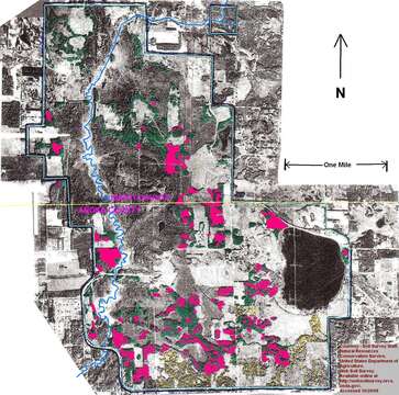
Description: English: Map shows red colored areas being oak wilt infected or killed; 500 of 1,100 acres of upland oak forest dead or dying of oak wilt disease. At University of Minnesota's Cedar Creek Ecosystem Science Reserve. One of the 3 largest oak wilt disease "Reservoirs" in Minnesota. Oak wilt disease delineation based on DNR 2007 color infrared photos and NRCS soils maps. This version shows the Isanti - Anoka county line. Date: 19 October 2013, 10:00:13. Source: Own work. Author: Firry Floyd.
Aşağıdaki Sayfalarda Bulunmaktadır:
- Life
- Cellular
- Eukaryota (Ökaryot)
- Opisthokonta
- Nucletmycea
- Fungi
- Dikarya
- Ascomycota (Asklı mantarlar)
- Sordariomycetes
- Microascales
- Ceratocystidaceae
- Ceratocystis
- Ceratocystis fagacearum
Bu resim hiçbir koleksiyonda yer almıyor.
Kaynak Bilgileri
- lisans
- cc-by-sa-3.0
- telif hakkı
- Firry Floyd
- oluşturan
- Firry Floyd
- orijinal
- orijinal medya dosyası
- kaynağı ziyaret et
- ortak site
- Wikimedia Commons
- ID