-
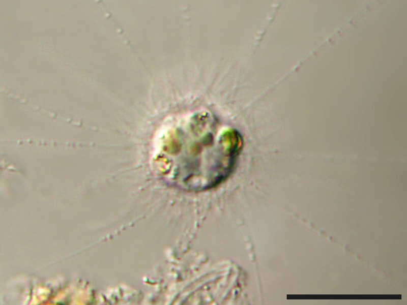
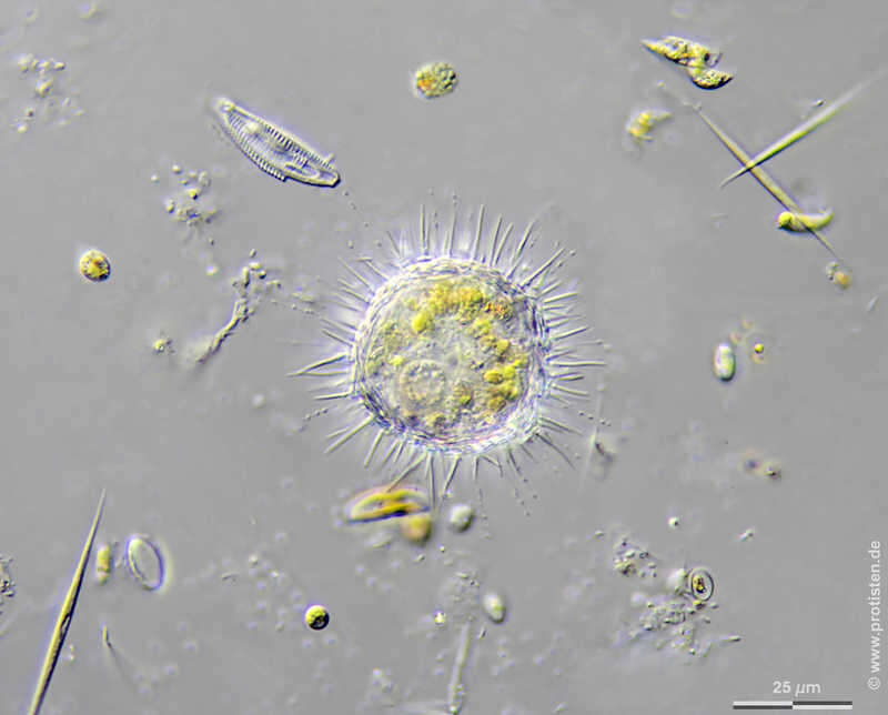
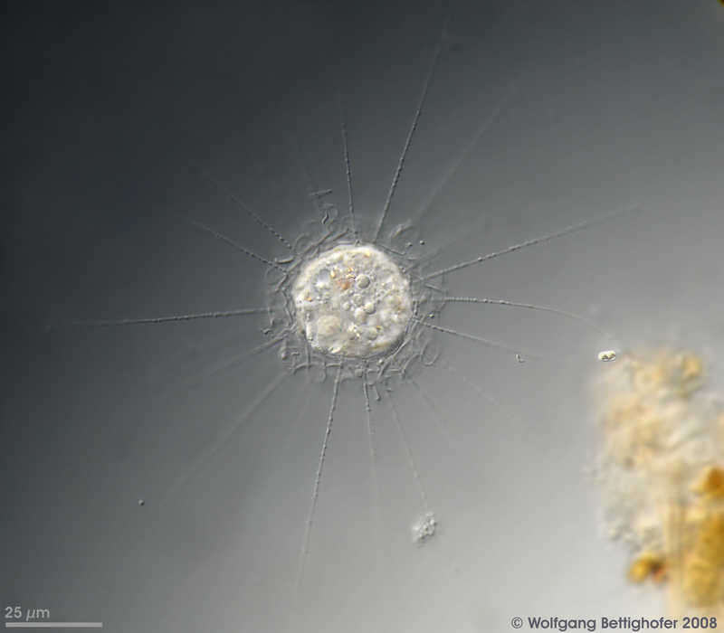
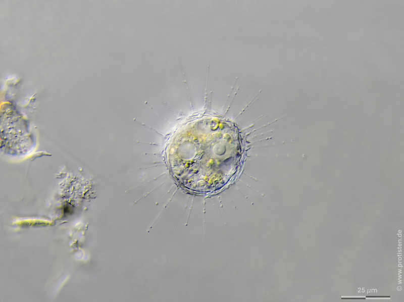
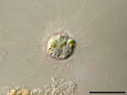
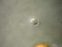
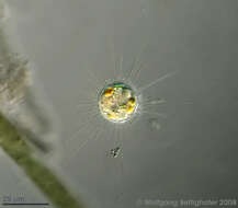
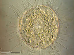
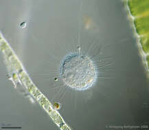
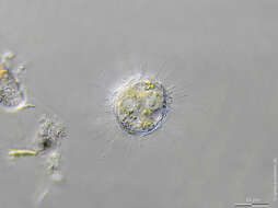
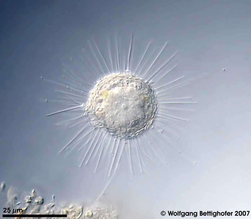
Sphaerastrum fockii Synonym: Heterophrys fockii.Scale bar indicates 25 µm. Sample from a small wetland near Schladming (northern alpine region of Austria near Salzburg). Images were taken using Zeiss Universal with Olympus C7070 CCD camera.Image under Creative Commons License V 3.0 (CC BY-NC-SA). Place name: Wetland near Schladming (Austria) Latitude: 47.37386 Longitude: 13.823016 Synonym: Heterophrys fockii.Der Messbalken markiert eine Länge von 50 µm. Probe aus einer Wiesenvernässung nahe Schladming/Österreich. Mikrotechnik: Zeiss Universal, Kamera: Olympus C7070. Creative Commons License V 3.0 (CC BY-NC-SA). For permission to use of (high-resolution) images please contact postmaster@protisten.de.
-
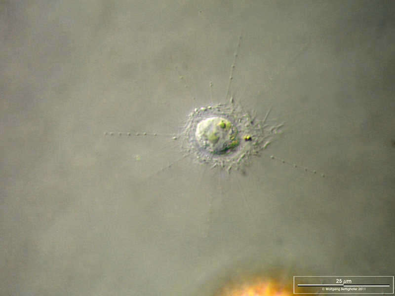
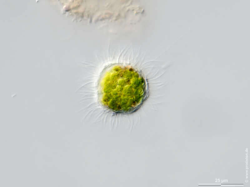
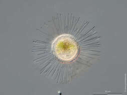
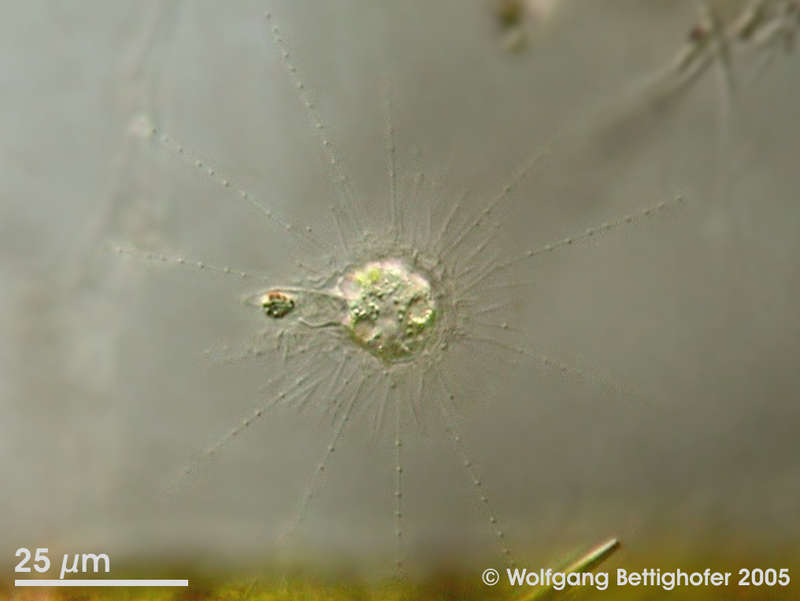
Raphidiophrys coerulea Scale bar indicates 25 µm. Sample from a pond situated in the vicinity of Lake Constance. The image was built up using several photomicrographic frames with manual stacking technique. Images were taken using Zeiss Universal with Olympus C7070 CCD camera.Image under Creative Commons License V 3.0 (CC BY-NC-SA). Place name: Pond situated in the vicinity of Lake Constance (Germany) Latitude: 47.734945 Longitude: 9.091097 Multiebenen-Abbildung, manuell gestapelt. Der Messbalken markiert eine Länge von 25 µm. Probe aus einem Teich in der Nähe des Bodensees. Mikrotechnik: Zeiss Universal, Kamera: Olympus C7070. Creative Commons License V 3.0 (CC BY-NC-SA). For permission to use of (high-resolution) images please contact postmaster@protisten.de.
-
Raphidocystis tubifera This centrohelid heliozoan is characterized by trumpet shaped siliceous skeleton elements. This specimen shows the enormous food vacuole production (funnel-shaped pseudopod) preceeding the ingestion process. Collected from littoral region (reed belt by Phragmites) of a rain storage reservoir in Kiel (Schleswig-Holstein, Germany). Images were taken using Zeiss Universal with Olympus C7070 CCD camera.Image under Creative Commons License V 3.0 (CC BY-NC-SA). Place name: Pond Demühlen, rain storage reservoir in Kiel-Russee (Schleswig-Holstein, Germany) Latitude: 54.304095 Longitude: 10.086073 Dieses Sonnentierchen der Gruppe Centrohelidae ist charakterisiert durch trompetenförmige Kieselnadeln. Dieses Exemplar zeigt die Ausbildung eines enorm großen trichterförmigen Pseudopodiums), welches die Beute umfließt und danach die Nahrungsvakuole bildet. Aus der von Schilf bewachsenen Uferzone eines Regenrückhaltebeckens in Kiel. Mikrotechnik: Zeiss Universal, Kamera: Olympus C7070. Creative Commons License V 3.0 (CC BY-NC-SA). For permission to use of (high-resolution) images please contact postmaster@protisten.de.
-
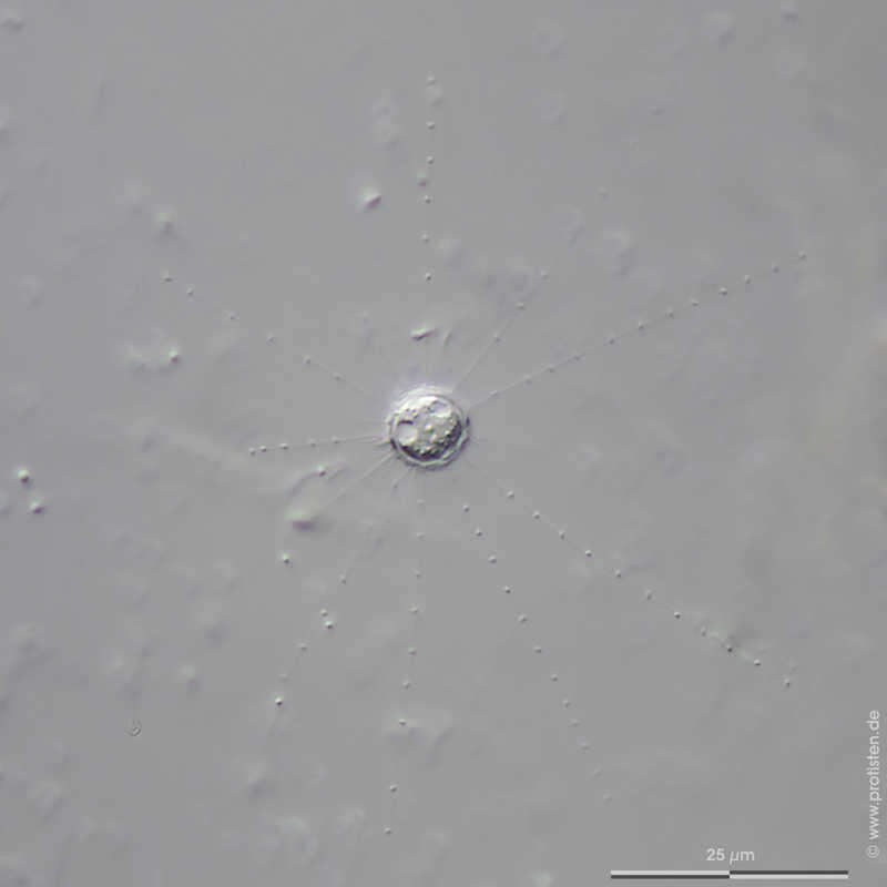
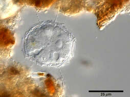
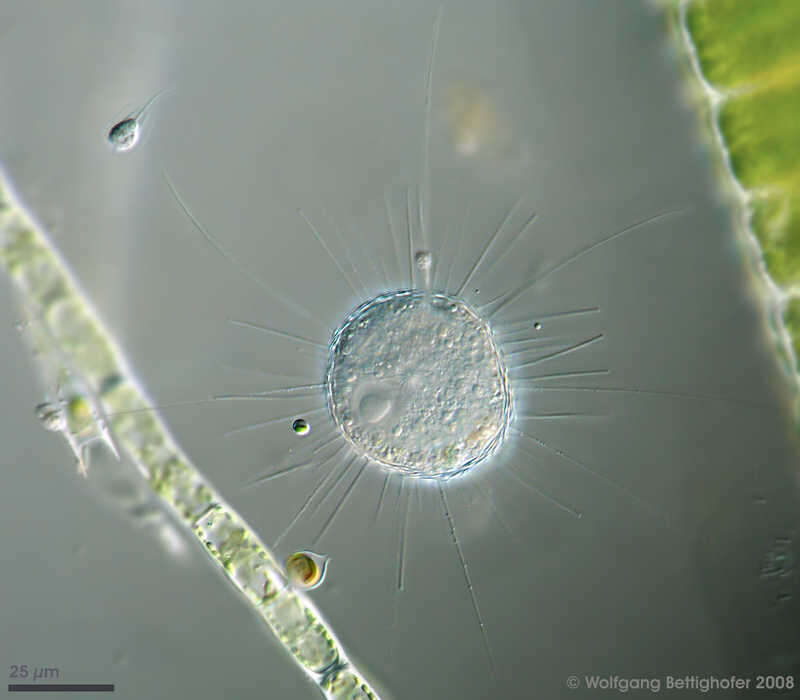
Choanocystis perpusilla Scale bar indicates 25 µm.Sample from the wetland Seekamper Seewiesen in Schilksee (Kiel, Germany). The image was built up using several photomicrographic frames with manual stacking technique. Images were taken using Zeiss Axioplan with Olympus OM-D M5 MKII.Image under Creative Commons License V 3.0 (CC BY-NC-SA). Place name: Wetland Seekamper Seewiesen in Schilksee (Kiel, Germany) Latitude: 54.410447 Longitude: 10.159699 Multiebenen-Abbildung, manuell gestapelt. Der Messbalken markiert eine Länge von 25 µm. Probe aus Feuchtbiotop Seekamper Seewiesen bei Schilksee/Kiel. Mikrotechnik: Zeiss Axioplan, Kamera: Olympus OM-D M5 MKII. Creative Commons License V 3.0 (CC BY-NC-SA). For permission to use of (high-resolution) images please contact postmaster@protisten.de.
-
Acanthocystis pectinata The picture shows the two types of actinomorphic siliceous spines (the shorter type is forked, see inset top right) and the tangential scales. Nucleus is clearly shown together with some food vacuoles. Scale bar indicates 25 µm. Sample from sphagnum pond Dosenmoor near Neumuenster (Schleswig-Holstein. Images were taken using Zeiss Universal with Olympus C7070 CCD camera.Image under Creative Commons License V 3.0 (CC BY-NC-SA). Place name: Bog Dosenmoor near Neumuenster (Schleswig-Holstein, Germany) Latitude: 54.136219 Longitude: 10.026433 Das Bild zeigt die beiden Arten der radiären kieselsäurehaltigen Stacheln (der kürzer Typ ist gegabelt, siehe Kasten oben rechts) und die tangentialen Kieselschuppen. Der Zellkern ist deutlich zu sehen, zusammen mit einigen Nahrungsvakuolen. Der Messbalken markiert eine Länge von 25 µm. Probe aus dem Dosenmoor in der Nähe von Neumünster. Mikrotechnik: Zeiss Universal, Kamera: Olympus C7070. Creative Commons License V 3.0 (CC BY-NC-SA). For permission to use of (high-resolution) images please contact postmaster@protisten.de.
-
Choanocystis aculeata Scale bar indicates 25 µm. The specimen was gathered in the wetlands of Nationalpark Unteres Odertal (100 km north east of Berlin). Sampling date 5/2019. The image was built up using several photomicrographic frames with manual stacking technique. Images were taken using Zeiss Axioplan with Olympus OM-D M5 MKII. Image under Creative Commons License V 3.0 (CC BY-NC-SA). Place name: Creek in Oder valley 100 km north east of Berlin (Germany) Latitude: 53.135032 Longitude: 14.348738 Multiebenen-Abbildung, manuell gestapelt. Der Messbalken markiert eine Länge von 25 µm. Probe aus einem Feuchtbiotop im Nationalpark Unteres Odertal auf halber Strecke zwischen Schwedt und Gartz. Datum der Aufsammlung: 7/2019. Mikrotechnik: Zeiss Axioplan, Kamera: Olympus OM-D M5 MKII. Creative Commons License V 3.0 (CC BY-NC-SA). For permission to use of (high-resolution) images please contact postmaster@protisten.de.
-
Choanocystis aculeata Spicula of Choanocystis aculeate. Scale bar indicates 10 µm. The specimen was gathered in the wetlands of Nationalpark Unteres Odertal (100 km north east of Berlin). Sampling date 5/2019. The image was built up using several photomicrographic frames with manual stacking technique. Images were taken using Zeiss Axioplan with Olympus OM-D M5 MKII. Image under Creative Commons License V 3.0 (CC BY-NC-SA). Place name: Creek in Oder valley 100 km north east of Berlin (Germany) Latitude: 53.135032 Longitude: 14.348738 Kieselschuppe (Spicula) von Choanocystis aculeate. Multiebenen-Abbildung, manuell gestapelt. Der Messbalken markiert eine Länge von 10 µm. Probe aus einem Feuchtbiotop im Nationalpark Unteres Odertal auf halber Strecke zwischen Schwedt und Gartz. Datum der Aufsammlung: 7/2019. Mikrotechnik: Zeiss Axioplan, Kamera: Olympus OM-D M5 MKII. Creative Commons License V 3.0 (CC BY-NC-SA). For permission to use of (high-resolution) images please contact postmaster@protisten.de.
-
Choanocystis aculeata Scale bar indicates 25 µm. The specimen was gathered in the wetlands of Nationalpark Unteres Odertal (100 km north east of Berlin). Sampling date 5/2019. The image was built up using several photomicrographic frames with manual stacking technique. Images were taken using Zeiss Axioplan with Olympus OM-D M5 MKII. Image under Creative Commons License V 3.0 (CC BY-NC-SA). Place name: Creek in Oder valley 100 km north east of Berlin (Germany) Latitude: 53.135032 Longitude: 14.348738 Multiebenen-Abbildung, manuell gestapelt. Der Messbalken markiert eine Länge von 25 µm. Probe aus einem Feuchtbiotop im Nationalpark Unteres Odertal auf halber Strecke zwischen Schwedt und Gartz. Datum der Aufsammlung: 7/2019. Mikrotechnik: Zeiss Axioplan, Kamera: Olympus OM-D M5 MKII. Creative Commons License V 3.0 (CC BY-NC-SA). For permission to use of (high-resolution) images please contact postmaster@protisten.de.
-
Choanocystis aculeata Scale bar indicates 25 µm. Collected from a pond near the Bodden bay Schwarzer Peter in the southern part of the isle Hiddensee (German Baltic Sea). Sampling date 10/2018. The image was built up using several photomicrographic frames with manual stacking technique. Images were taken using Zeiss Standard with Olympus OM-D M5 MKII. Image under Creative Commons License V 3.0 (CC BY-NC-SA). Place name: Pond near the Bodden bay Schwarzer Peter, Hiddensee (German Baltic Sea) Latitude: 54.514946 Longitude: 13.082471 Multiebenen-Abbildung, manuell gestapelt. Der Messbalken markiert eine Länge von 25 µm. Probe aus einem Teich nahe der Boddenbucht Schwarzer Peter auf Hiddensee. Datum der Aufsammlung: 10/2018. Mikrotechnik: Zeiss Standard, Kamera: Olympus OM-D M5 MKII. Creative Commons License V 3.0 (CC BY-NC-SA). For permission to use of (high-resolution) images please contact postmaster@protisten.de.
-
Choanocystis aculeata Scale bar indicates 25 µm. Sample from Kaltenhof Bog in the north of Kiel, Germany. Sampling date 9/2018. The image was built up using several photomicrographic frames with manual stacking technique. Images were taken using Zeiss Axioplan with Olympus OM-D M5 MKII. Image under Creative Commons License V 3.0 (CC BY-NC-SA). Place name: Bog Kaltenhof near Kiel (Schleswig-Holstein, Germany) Latitude: 54.42102744 Longitude: 10.07686615 Multiebenen-Abbildung, manuell gestapelt. Der Messbalken markiert eine Länge von 25 µm. Probe aus dem Kaltenhofer Moor nördlich von Kiel. Datum der Aufsammlung: 9/2018. Mikrotechnik: Zeiss Axioplan, Kamera: Olympus OM-D M5 MKII. Creative Commons License V 3.0 (CC BY-NC-SA). For permission to use of (high-resolution) images please contact postmaster@protisten.de.
-
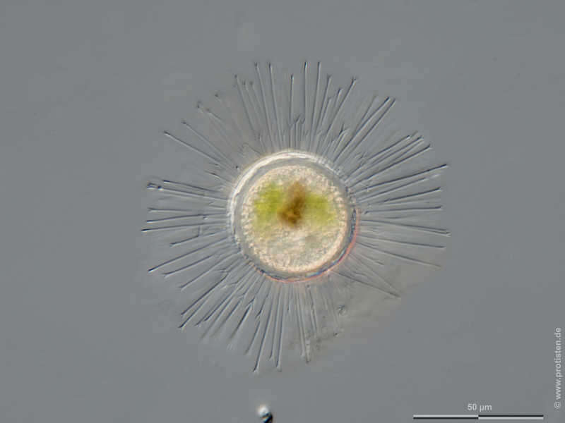
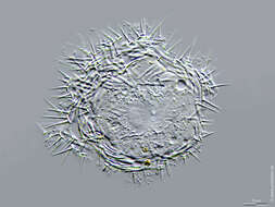
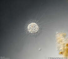
Acanthocystis turfacea Scale bar indicates 50 µm. Sample from Bog Waasenmoos Pass Thurn near Mittersil, Tyrol, Austria. Sampling date 10/2019. The image was built up using several photomicrographic frames with manual stacking technique. Images were taken using Zeiss Axioplan with Olympus OM-D M5 MKII. Image under Creative Commons License V 3.0 (CC BY-NC-SA). Place name: Bog Waasenmoos Pass Thurn near Mittersil (Tyrol, Austria) Latitude: 47.30234117 Longitude: 12.41751194 Multiebenen-Abbildung, manuell gestapelt. Der Messbalken markiert eine Länge von 50 µm. Probe aus dem Waasenmoos bei Pass Thurn Nähe Mittersil, Tirol. Datum der Aufsammlung: 10/2019. Mikrotechnik: Zeiss Axioplan, Kamera: Olympus OM-D M5 MKII. Creative Commons License V 3.0 (CC BY-NC-SA). For permission to use of (high-resolution) images please contact postmaster@protisten.de.
-
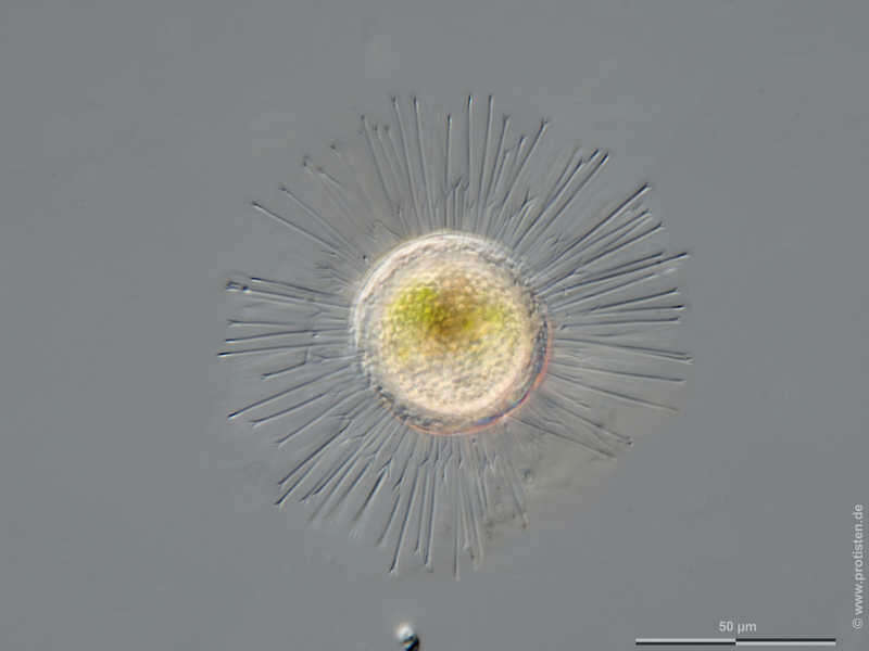
Acanthocystis turfacea Scale bar indicates 50 µm.Sample from a wetland at the Pillersee (Tyrol, Austria). The image was built up using several photomicrographic frames with manual stacking technique. Images were taken using Zeiss Universal with Olympus C7070 CCD camera.Image under Creative Commons License V 3.0 (CC BY-NC-SA). Place name: Wetland at the Pillersee (Tyrol, Austria) Latitude: 47.531785 Longitude: 12.573095 Multiebenen-Abbildung, manuell gestapelt. Der Messbalken markiert eine Länge von 50 µm. Probe aus einer Feuchtwiese beim Pillersee in Tirol. Mikrotechnik: Zeiss Universal, Kamera: Olympus C7070. Creative Commons License V 3.0 (CC BY-NC-SA). For permission to use of (high-resolution) images please contact postmaster@protisten.de.
-
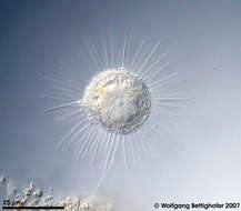
Acanthocystis turfacea Scale bar indicates 50 µm. Sample from Bog Waasenmoos Pass Thurn near Mittersil, Tyrol, Austria. Sampling date 10/2019. The image was built up using several photomicrographic frames with manual stacking technique. Images were taken using Zeiss Axioplan with Olympus OM-D M5 MKII. Image under Creative Commons License V 3.0 (CC BY-NC-SA). Place name: Bog Waasenmoos Pass Thurn near Mittersil (Tyrol, Austria) Latitude: 47.30234117 Longitude: 12.41751194 Multiebenen-Abbildung, manuell gestapelt. Der Messbalken markiert eine Länge von 50 µm. Probe aus dem Waasenmoos bei Pass Thurn Nähe Mittersil, Tirol. Datum der Aufsammlung: 10/2019. Mikrotechnik: Zeiss Axioplan, Kamera: Olympus OM-D M5 MKII. Creative Commons License V 3.0 (CC BY-NC-SA). For permission to use of (high-resolution) images please contact postmaster@protisten.de.
-
Raphidocystis marginata Synonym: Raphidiophrys marginata.Centroplast (star in the middle of the cell), nucleus on the right of the centroplast, and contractile vacuoles. Scale bar indicates 25 µm. Sample from a pond near Berlin. This image was taken by Eckhard Völcker, Berlin. Copyright by Eckhard Völcker, Berlin. Place name: Pond near Berlin (Germany) Latitude: 0 Longitude: 0 Synonym: Raphidiophrys marginata.Centroplast (Stern in der Mitte der Zelle), der Kern liegt auf der rechten Seite des Centroplast. Zwei kontraktile Vakuolen sind im unteren Teil der Zelle zu sehen. Der Messbalken markiert eine Länge von 25 µm. Probe aus einem Teich in der Nähe von Berlin. Dieses Bild wurde von Eckhard Völcker, Berlin aufgenommen. Urheberrecht Eckhard Völcker, Berlin. For permission to use of (high-resolution) images please contact postmaster@protisten.de.
-
Raphidocystis marginata Synonym: Raphidiophrys marginata.Scale bar indicates 25 µm. Sample from a pond near Berlin. This image was taken by Eckhard Völcker, Berlin. Copyright Eckhard Völcker, Berlin. Place name: Pond near Berlin (Germany) Latitude: 0 Longitude: 0 Synonym: Raphidiophrys marginata.Der Messbalken markiert eine Länge von 25 µm. Probe aus einem Teich in der Nähe von Berlin. Dieses Bild wurde von Eckhard Völcker, Berlin aufgenommen. Urheberrecht bei Eckhard Völcker, Berlin. For permission to use of (high-resolution) images please contact postmaster@protisten.de.
-
Raphidiophrys elegans The picture shows the characteristic layer of mucilage armed with siliceous scales around the cell body and the narrow axopodia with numerous extrusomes. Sample from sphagnum pond situated in the northern alpine region of Austria near Salzburg. Images were taken using Zeiss Universal with Olympus C7070 CCD camera.Image under Creative Commons License V 3.0 (CC BY-NC-SA). Place name: Bogs near Salzburg (Austria) Latitude: 48.068516 Longitude: 12.954134 Das Bild zeigt die charakteristische Schleimhülle, verstärkt durch kieselige Schuppen, und die feinen Axopodien, die mit zahlreichen Extrusomen bewaffnet sind. Probe aus einem Moor in den nördlichen Kalkalpen von Österreich in der Nähe von Salzburg. Mikrotechnik: Zeiss Universal, Kamera: Olympus C7070. Creative Commons License V 3.0 (CC BY-NC-SA). For permission to use of (high-resolution) images please contact postmaster@protisten.de.
-
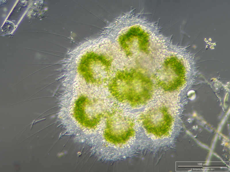
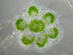
Raphidiophrys viridis Zoom-in showing one member of th colony with its silicious spiculae and the zoochlorellae. Scale bar indicates 100 µm. Sample from the pond Hegne Moor situated in the vicinity of Lake Constance. The image was built up using several photomicrographic frames with manual stacking technique. Images were taken using Zeiss Universal with Olympus C7070 CCD camera.Image under Creative Commons License V 3.0 (CC BY-NC-SA). Place name: Bog Hegne Moor near Lake Constance (Germany) Latitude: 47.718106 Longitude: 9.093974 Die Ausschnittsvergrößerung zeigt die SIlikatschuppen und die Zoochlorellen. Multiebenen-Abbildung, manuell gestapelt. Der Messbalken markiert eine Länge von 100 µm. Probe aus dem Simmelried nahe Konstanz. Mikrotechnik: Zeiss Universal, Kamera: Olympus C7070. Creative Commons License V 3.0 (CC BY-NC-SA). For permission to use of (high-resolution) images please contact postmaster@protisten.de.
-
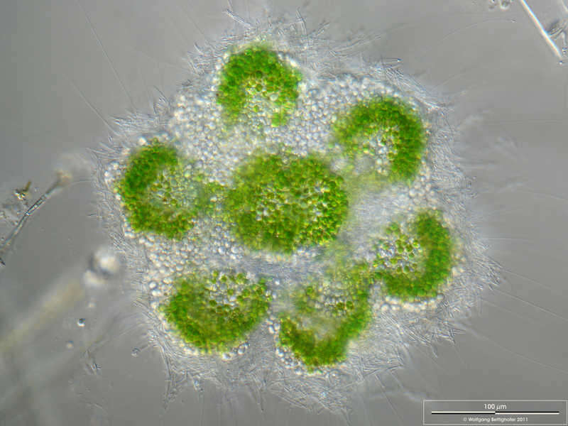
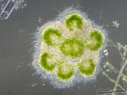
Raphidiophrys viridis Colony. Scale bar indicates 100 µm. Sample from the pond Hegne Moor situated in the vicinity of Lake Constance. The image was built up using several photomicrographic frames with manual stacking technique. Images were taken using Zeiss Universal with Olympus C7070 CCD camera.Image under Creative Commons License V 3.0 (CC BY-NC-SA). Place name: Bog Hegne Moor near Lake Constance (Germany) Latitude: 47.718106 Longitude: 9.093974 Zellkolonie. Multiebenen-Abbildung, manuell gestapelt. Der Messbalken markiert eine Länge von 100 µm. Probe aus dem Simmelried nahe Konstanz. Mikrotechnik: Zeiss Universal, Kamera: Olympus C7070. Creative Commons License V 3.0 (CC BY-NC-SA). For permission to use of (high-resolution) images please contact postmaster@protisten.de.
-
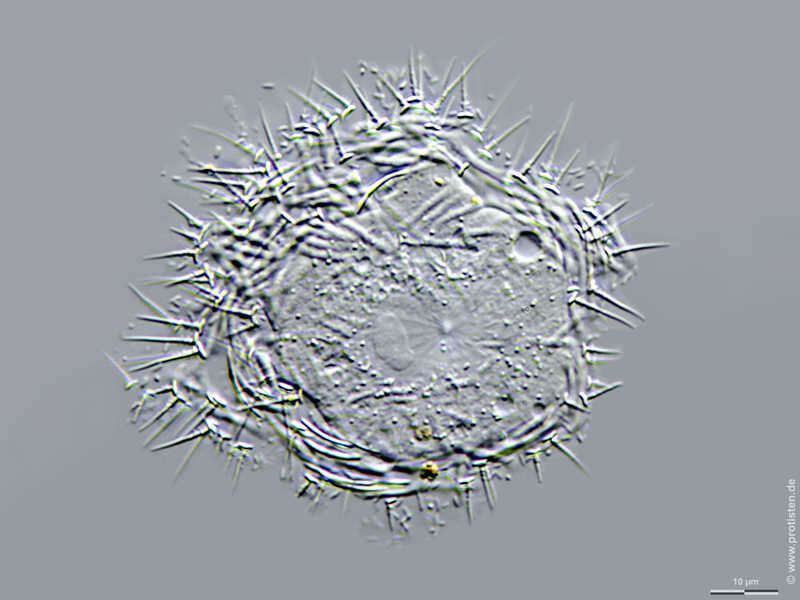
Acanthocystis penardi Acanthocystis penardi shows numerous siliceous spines and scales inserting and lying respectively upon the surface of the cell forming the periplast. The central body from which all the axopodia originate is clearly visible. Scale bar indicates 25 µm. Sample from sphagnum pond Dosenmoor near Neumuenster (Schleswig-Holstein, Germany). Images were taken using Zeiss Universal with Olympus C7070 CCD camera.Image under Creative Commons License V 3.0 (CC BY-NC-SA). Place name: Bog Dosenmoor near Neumuenster (Schleswig-Holstein, Germany) Latitude: 54.136219 Longitude: 10.026433 Acanthocystis penardi trägt zahlreiche kieselsäurehaltigen Stacheln und Schuppen, die auf der Oberfläche der Zelle ansetzen bzw. liegen und den Periplast formen. Der Zentralkörper, von dem alle Axopodien ausgehen, ist deutlich sichtbar. Der Messbalken markiert eine Länge von 25 µm. Probe aus dem Dosenmoor in der Nähe von Neumünster. Mikrotechnik: Zeiss Universal, Kamera: Olympus C7070. Creative Commons License V 3.0 (CC BY-NC-SA). For permission to use of (high-resolution) images please contact postmaster@protisten.de.
-
Acanthocystis penardi Acanthocystis penardi shows numerous siliceous spines and scales inserting and lying respectively upon the surface of the cell forming the periplast. The nucleus and several narrow axopodia are clearly visible, also a free swimming Salpingoeca species and a Chrysophyta called Chrysopyxis inaequalis fixed on a Tribonema filament with a mucilaginous string. Scale bar indicates 25 µm. Sample from sphagnum pond Dosenmoor near Neumuenster (Schleswig-Holstein, Germany). Images were taken using Zeiss Universal with Olympus C7070 CCD camera.Image under Creative Commons License V 3.0 (CC BY-NC-SA). Place name: Bog Dosenmoor near Neumuenster (Schleswig-Holstein, Germany) Latitude: 54.136219 Longitude: 10.026433 Acanthocystis penardi trägt zahlreiche kieselsäurehaltigen Stacheln und Schuppen, die auf der Oberfläche der Zelle ansetzen bzw. liegen und den Periplast formen. Der Kern und mehrere dünne Axopodien sind deutlich sichtbar, des Weiteren eine frei schwimmende Salpingoeca-Art und eine Chrysophycee namens Chrysopyxis inaequalis, die sich mit einem Gallertfaden auf einem Algenfaden (Tribonema) befestigt hat. Der Messbalken markiert eine Länge von 25 µm. Probe aus dem Dosenmoor in der Nähe von Neumünster. Mikrotechnik: Zeiss Universal, Kamera: Olympus C7070. Creative Commons License V 3.0 (CC BY-NC-SA). For permission to use of (high-resolution) images please contact postmaster@protisten.de.
-

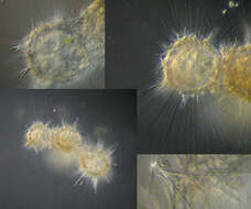
Raphidocystis pallida Synonym: Raphidiophrys pallida.Three specimen living close together in a feeding community on the neuston, the biofilm on the water surface. Axopodia and silicious scales are clearly visible. Diameter of one body is appr. 100 µm. Sample from a pond on the island of Hiddensee (Baltic Sea, Germany). This image was taken using Zeiss Universal with Olympus C7070 CCD camera.Image under Creative Commons License V 3.0 (CC BY-NC-SA). Place name: Pond Suploch, Hiddensee (Germany) Latitude: 54.538638 Longitude: 13.097802 Synonym: Raphidiophrys pallida.Drei Zellen von bilden eine Fressgemeinschaft im Neuston, dem Biofilm an der Wasseroberfläche. Axopodien und Silikatschuppen sind deutlich sichtbar. Durchmesser von einem Zellkörper ist ca. 100 µm. Probe aus einem Teich auf der Insel Hiddensee. Mikrotechnik: Zeiss Universal, Kamera: Olympus C7070. Creative Commons License V 3.0 (CC BY-NC-SA). For permission to use of (high-resolution) images please contact postmaster@protisten.de.
-
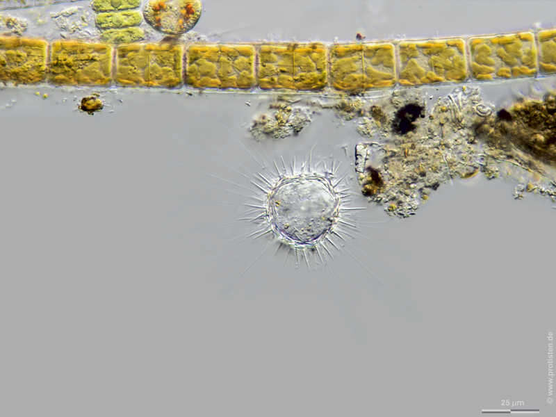
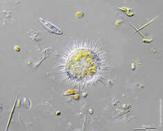
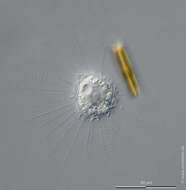
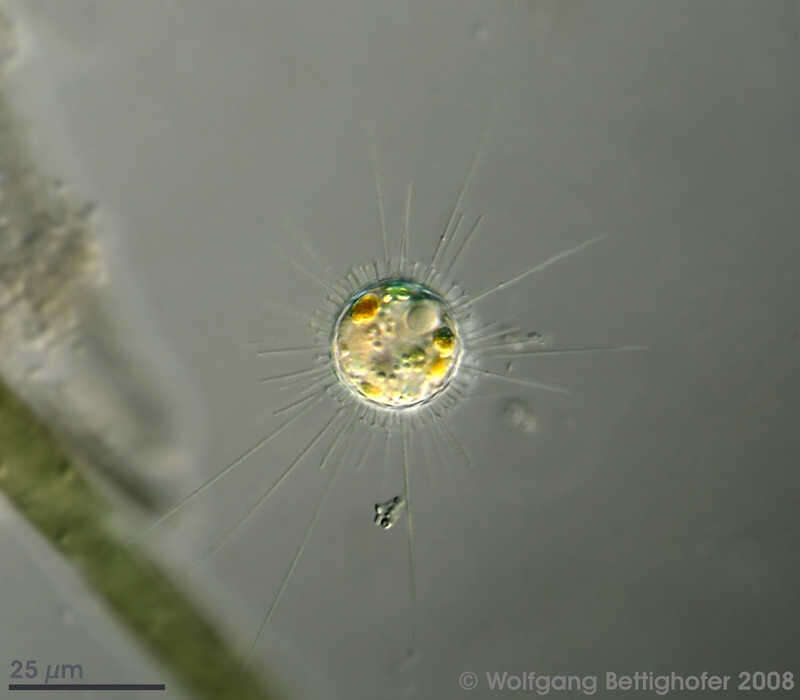
Raphidiophrys capitata Scale bar indicates 50 µm.Sample from a tropical freshwater aquarium. Images were taken using Zeiss Axioplan with Olympus OM-D M5 MKII.Image under Creative Commons License V 3.0 (CC BY-NC-SA). Place name: Tropical freshwater aquarium Latitude: 54.3018013 Longitude: 10.07120132 Multiebenen-Abbildung, manuell gestapelt. Der Messbalken markiert eine Länge von 50 µm. Probe aus einem Süßwasseraquarium für tropische Fische. Mikrotechnik: Zeiss Axioplan, Kamera: Olympus OM-D M5 MKII. Creative Commons License V 3.0 (CC BY-NC-SA). For permission to use of (high-resolution) images please contact postmaster@protisten.de.
-
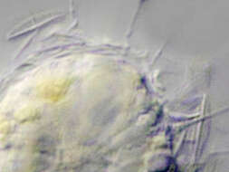
Raphidiophrys capitata Close-up with silicious scales. Sample from an on-site preflooder on the island of Hiddensee south of the village Kloster. Sampling date 9/2022. Images were taken using Zeiss Universal with Olympus OM-D M5 MKII.Image under Creative Commons License V 3.0 (CC BY-NC-ND). Place name: Preflooder south of the village Kloster, Hiddensee (German Baltic Sea) Latitude: 54.57611642 Longitude: 13.11450005 Ausschnitt mit Silikatschuppen. Probe aus einem Bodden-Vorfluter auf Hiddensee südlich von Kloster. Datum der Aufsammlung: 9/2022. Mikrotechnik: Zeiss Universal, Kamera: Olympus OM-D M5 MKII. Creative Commons License V 3.0 (CC BY-NC-ND). For permission to use of (high-resolution) images please contact postmaster@protisten.de.
-
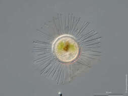
Raphidiophrys capitata Scale bar indicates 25 µm. Collected from a pond near the Bodden bay Schwarzer Peter in the southern part of the isle Hiddensee (German Baltic Sea). Sampling date 10/2018. The image was built up using several photomicrographic frames with manual stacking technique. Images were taken using Zeiss Standard with Olympus OM-D M5 MKII. Image under Creative Commons License V 3.0 (CC BY-NC-SA). Place name: Pond near the Bodden bay Schwarzer Peter, Hiddensee (German Baltic Sea) Latitude: 54.514946 Longitude: 13.082471 Multiebenen-Abbildung, manuell gestapelt. Der Messbalken markiert eine Länge von 25 µm. Probe aus einem Teich nahe der Boddenbucht Schwarzer Peter auf Hiddensee. Datum der Aufsammlung: 10/2018. Mikrotechnik: Zeiss Standard, Kamera: Olympus OM-D M5 MKII. Creative Commons License V 3.0 (CC BY-NC-SA). For permission to use of (high-resolution) images please contact postmaster@protisten.de.