-
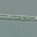
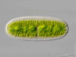
Cylindrocystis brebissonii Scale bar indicates 25 µm. Sample from the wetland at Grünbichel near Pillersee (Tyrol, Austria). The image was built up using several photomicrographic frames with manual stacking technique. Images were taken using Zeiss Universal with Olympus C7070 CCD camera.Image under Creative Commons License V 3.0 (CC BY-NC-SA). Place name: Wetland Grünbichel near Fieberbrunn (Tyrol, Austria) Latitude: 47.484885 Longitude: 12.546114 Der Messbalken markiert eine Länge von 25 µm. Probe aus einer Feuchtwiese beim Grünbichel Nähe Pillersee in Tirol. Mikrotechnik: Zeiss Universal, Kamera: Olympus C7070. Creative Commons License V 3.0 (CC BY-NC-SA). For permission to use of (high-resolution) images please contact postmaster@protisten.de.
-
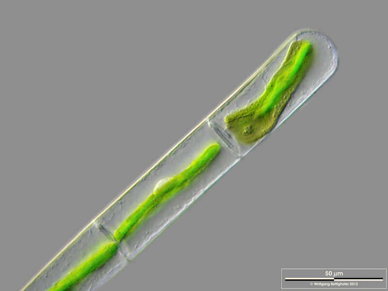
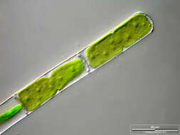
Mougeotia spec. The scale bar indicates 50 µm. Collected from a pond near the Bodden bay Schwarzer Peter in the southern part of the isle Hiddensee (German Baltic Sea). This image was taken using Zeiss Axioplan with Olympus OM-D M5 MKII.Image under Creative Commons License V 3.0 (CC BY-NC-SA). Place name: Pond near the Bodden bay Schwarzer Peter, Hiddensee (German Baltic Sea) Latitude: 54.514946 Longitude: 13.082471 Der Messbalken markiert eine Länge von 50 µm. Probe aus einem Teich nahe der Boddenbucht Schwarzer Peter auf Hiddensee. Mikrotechnik: Zeiss Axioplan, Kamera: Olympus OM-D M5 MKII. Creative Commons License V 3.0 (CC BY-NC-SA). For permission to use of (high-resolution) images please contact postmaster@protisten.de.
-
Mougeotia spec. The specimen was gathered in the wetlands of national park Unteres Odertal (100 km north east of Berlin). The image was built up using several photomicrographic frames with manual stacking technique. Images were taken using Zeiss Universal with Olympus C7070 CCD camera. Image under Creative Commons License V 3.0 (CC BY-NC-SA). Place name: Creek in Oder valley 100 km north east of Berlin (Germany) Latitude: 53.135032 Longitude: 14.348738 Die Probe wurde in den Feuchtgebieten des Nationalpark Unteres Odertal (100 km nordöstlich von Berlin) gesammelt. Mikrotechnik: Zeiss Universal, Kamera: Olympus C7070. Creative Commons License V 3.0 (CC BY-NC-SA). For permission to use of (high-resolution) images please contact postmaster@protisten.de.
-
Mougeotia spec. The scale bar indicates 50 µm. Collected from a pond near the Bodden bay Schwarzer Peter in the southern part of the isle Hiddensee (German Baltic Sea). This image was taken using Zeiss Axioplan with Olympus OM-D M5 MKII.Image under Creative Commons License V 3.0 (CC BY-NC-SA). Place name: Pond near the Bodden bay Schwarzer Peter, Hiddensee (German Baltic Sea) Latitude: 54.514946 Longitude: 13.082471 Der Messbalken markiert eine Länge von 50 µm. Probe aus einem Teich nahe der Boddenbucht Schwarzer Peter auf Hiddensee. Mikrotechnik: Zeiss Axioplan, Kamera: Olympus OM-D M5 MKII. Creative Commons License V 3.0 (CC BY-NC-SA). For permission to use of (high-resolution) images please contact postmaster@protisten.de.
-
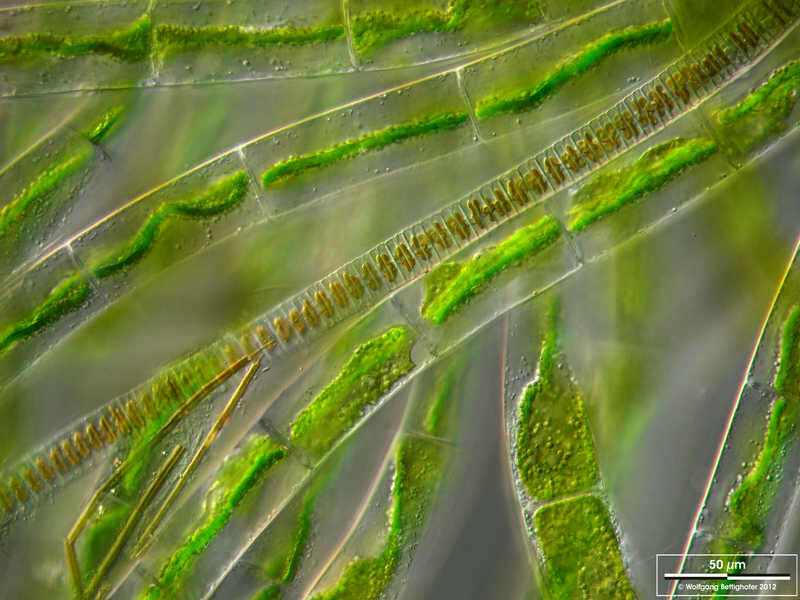
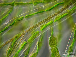
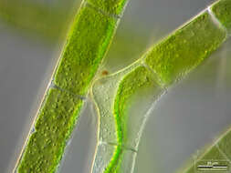
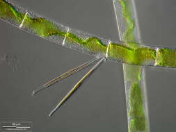
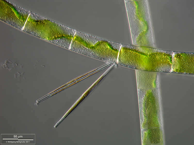
Mougeotia spec. Mougeotia accompanied by the diatom Fragilaria ulna. The scale bar indicates 50 µm. The specimen was gathered in the wetlands of national park Unteres Odertal (100 km north east of Berlin). The image was built up using several photomicrographic frames with manual stacking technique. Images were taken using Zeiss Universal with Olympus C7070 CCD camera.Image under Creative Commons License V 3.0 (CC BY-NC-SA). Place name: Creek in Oder valley 100 km north east of Berlin (Germany) Latitude: 53.135032 Longitude: 14.348738 Mougeotia zusammen mit der Diatomee Fragilaria ulna. Multiebenen-Abbildung, manuell gestapelt. Der Messbalken markiert eine Länge von 10 µm. Die Probe wurde in den Feuchtgebieten des Nationalpark Unteres Odertal (100 km nordöstlich von Berlin) gesammelt. Mikrotechnik: Zeiss Universal, Kamera: Olympus C7070. Creative Commons License V 3.0 (CC BY-NC-SA). For permission to use of (high-resolution) images please contact postmaster@protisten.de.
-
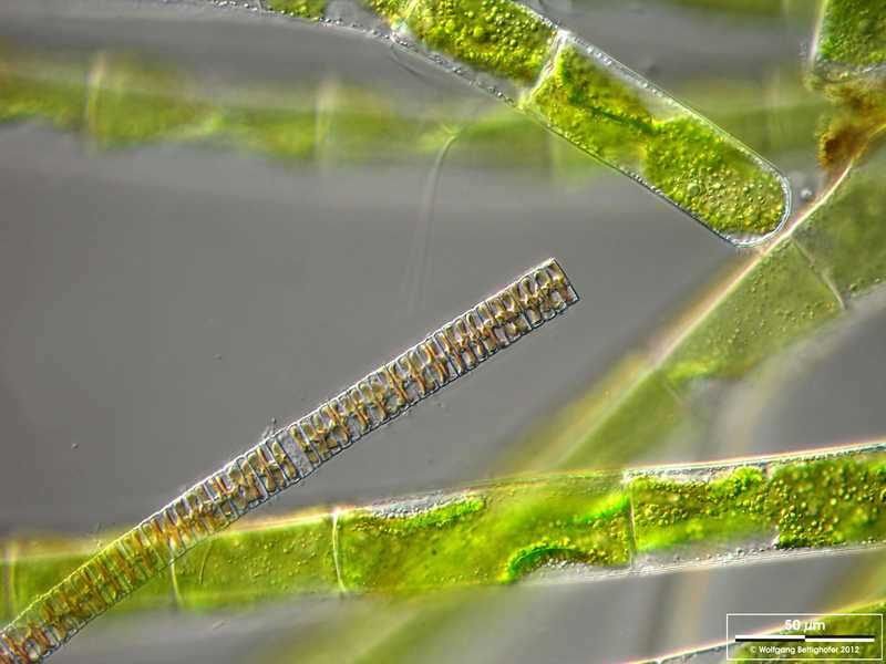
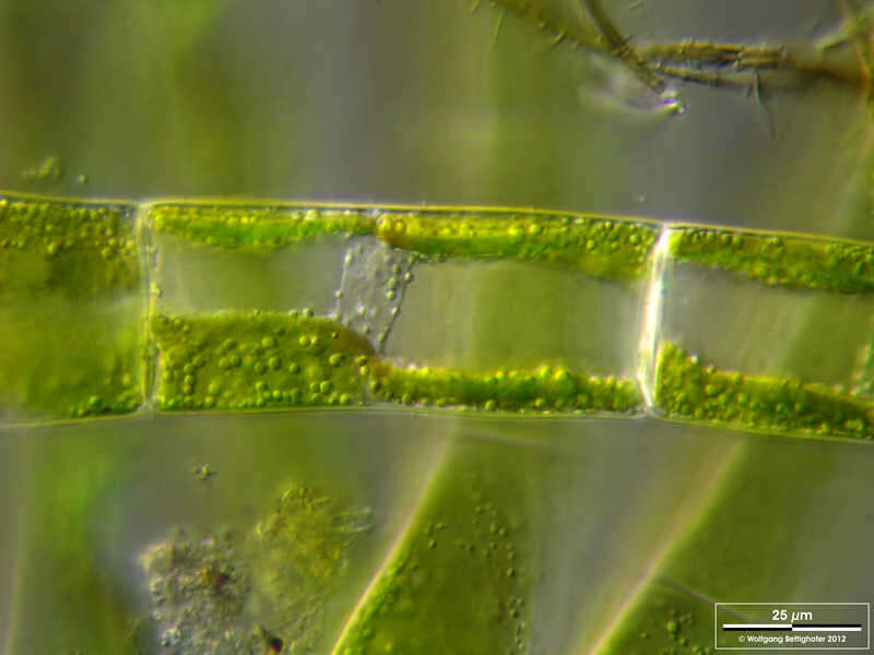
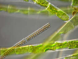
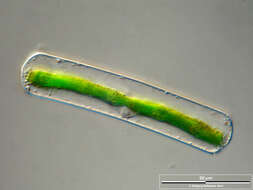
Mougeotia spec. Scale bar indicates 25 µm.The specimen was gathered in the wetlands of national park Unteres Odertal (100 km north east of Berlin). The image was built up using several photomicrographic frames with manual stacking technique. Images were taken using Zeiss Universal with Olympus C7070 CCD camera. Image under Creative Commons License V 3.0 (CC BY-NC-SA). Place name: Creek in Oder valley 100 km north east of Berlin (Germany) Latitude: 53.135032 Longitude: 14.348738 Multiebenen-Abbildung, manuell gestapelt. Der Messbalken markiert eine Länge von 25 µm. Die Probe wurde in den Feuchtgebieten des Nationalpark Unteres Odertal (100 km nordöstlich von Berlin) gesammelt. Mikrotechnik: Zeiss Universal, Kamera: Olympus C7070. Creative Commons License V 3.0 (CC BY-NC-SA). For permission to use of (high-resolution) images please contact postmaster@protisten.de.
-
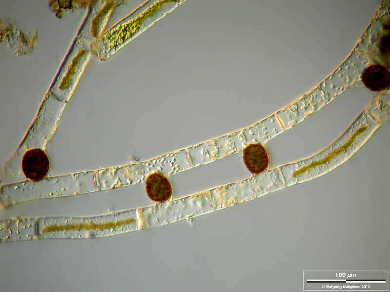
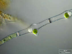
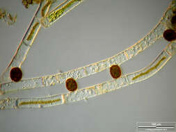
Mougeotia spec. Zygotes after conjugation. Scale bar indicates 100 µm.Sample from a wetland at the Pillersee (Tyrol, Austria). The image was built up using several photomicrographic frames with manual stacking technique. Images were taken using Zeiss Universal with Olympus C7070 CCD camera.Image under Creative Commons License V 3.0 (CC BY-NC-SA). Place name: Wetland at the Pillersee (Tyrol, Austria) Latitude: 47.531785 Longitude: 12.573095 Zygoten nach Konjugation. Multiebenen-Abbildung, manuell gestapelt. Der Messbalken markiert eine Länge von 100 µm. Probe aus einer Feuchtwiese beim Pillersee in Tirol. Mikrotechnik: Zeiss Universal, Kamera: Olympus C7070. Creative Commons License V 3.0 (CC BY-NC-SA). For permission to use of (high-resolution) images please contact postmaster@protisten.de.
-
Mougeotia spec. The scale bar indicates 50 µm. Collected from a pond near the Bodden bay Schwarzer Peter in the southern part of the isle Hiddensee (German Baltic Sea). This image was taken using Zeiss Axioplan with Olympus OM-D M5 MKII.Image under Creative Commons License V 3.0 (CC BY-NC-SA). Place name: Pond near the Bodden bay Schwarzer Peter, Hiddensee (German Baltic Sea) Latitude: 54.514946 Longitude: 13.082471 Der Messbalken markiert eine Länge von 50 µm. Probe aus einem Teich nahe der Boddenbucht Schwarzer Peter auf Hiddensee. Mikrotechnik: Zeiss Axioplan, Kamera: Olympus OM-D M5 MKII. Creative Commons License V 3.0 (CC BY-NC-SA). For permission to use of (high-resolution) images please contact postmaster@protisten.de.
-
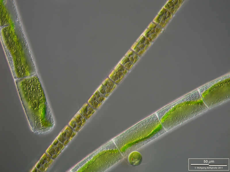
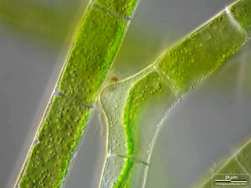
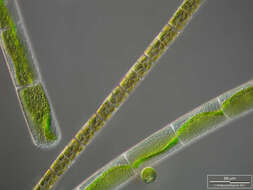
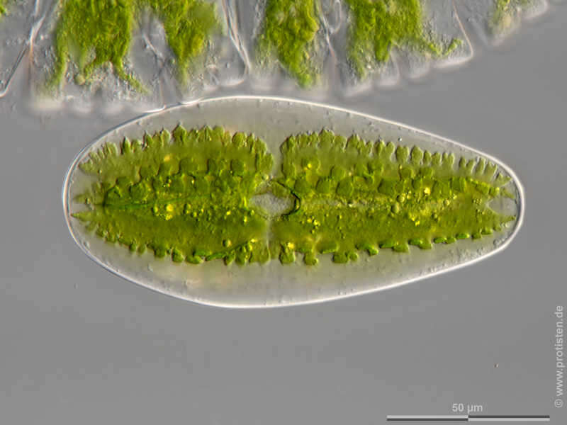
Mougeotia spec. Mougeotia accompanied by the diatom Melosira varians and a flagellated green alga Chlamydomonas. The scale bar indicates 50 µm. The specimen was gathered in the wetlands of national park Unteres Odertal (100 km north east of Berlin). The image was built up using several photomicrographic frames with manual stacking technique. Images were taken using Zeiss Universal with Olympus C7070 CCD camera.Image under Creative Commons License V 3.0 (CC BY-NC-SA). Place name: Creek in Oder valley 100 km north east of Berlin (Germany) Latitude: 53.135032 Longitude: 14.348738 Mougeotia zusammen mit der Diatomee Melosira varians und einer Geißel tragenden Grünalge Chlamydomonas. Multiebenen-Abbildung, manuell gestapelt. Der Messbalken markiert eine Länge von 50 µm. Die Probe wurde in den Feuchtgebieten des Nationalpark Unteres Odertal (100 km nordöstlich von Berlin) gesammelt. Mikrotechnik: Zeiss Universal, Kamera: Olympus C7070. Creative Commons License V 3.0 (CC BY-NC-SA). For permission to use of (high-resolution) images please contact postmaster@protisten.de.
-
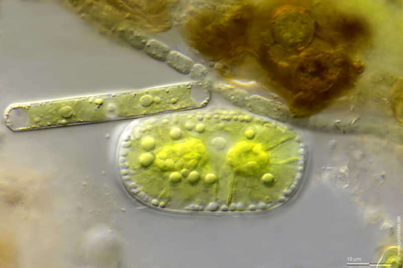
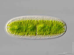
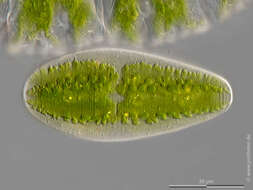
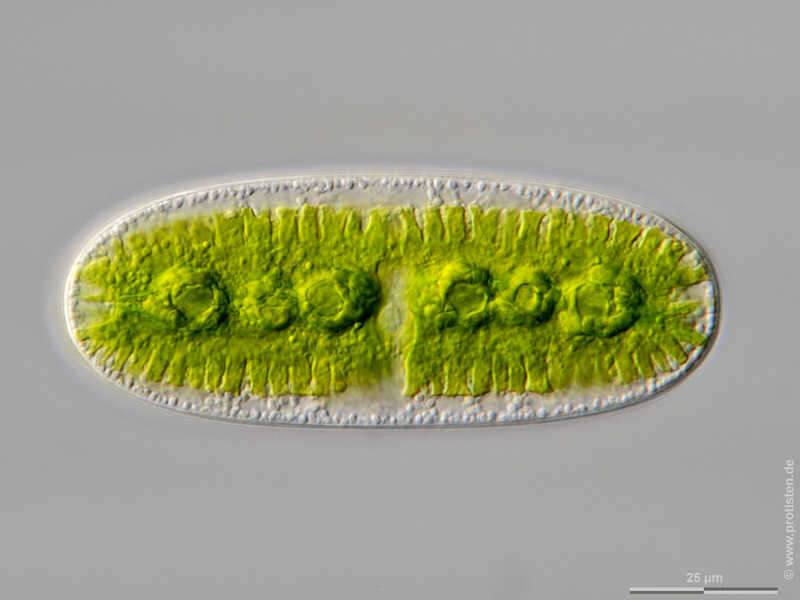
Cylindrocystis crassa Scale bar indicates 10 µm. Sample from the wetland at Mittermoos near Pillersee (Tyrol, Austria). The image was built up using several photomicrographic frames with manual stacking technique. Images were taken using Zeiss Universal with Olympus C7070 CCD camera.Image under Creative Commons License V 3.0 (CC BY-NC-SA). Place name: Wetland Mittermoos near Fieberbrunn (Tyrol, Austria) Latitude: 47.47998695 Longitude: 12.5240922 Der Messbalken markiert eine Länge von 10 µm. Probe aus einer Feuchtwiese beim Mittermoos Nähe Pillersee in Tirol. Mikrotechnik: Zeiss Universal, Kamera: Olympus C7070. Creative Commons License V 3.0 (CC BY-NC-SA). For permission to use of (high-resolution) images please contact postmaster@protisten.de.
-
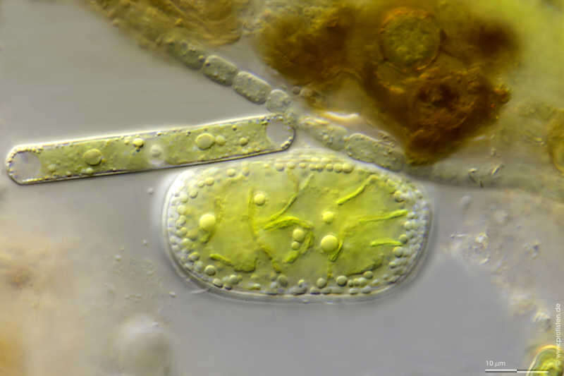
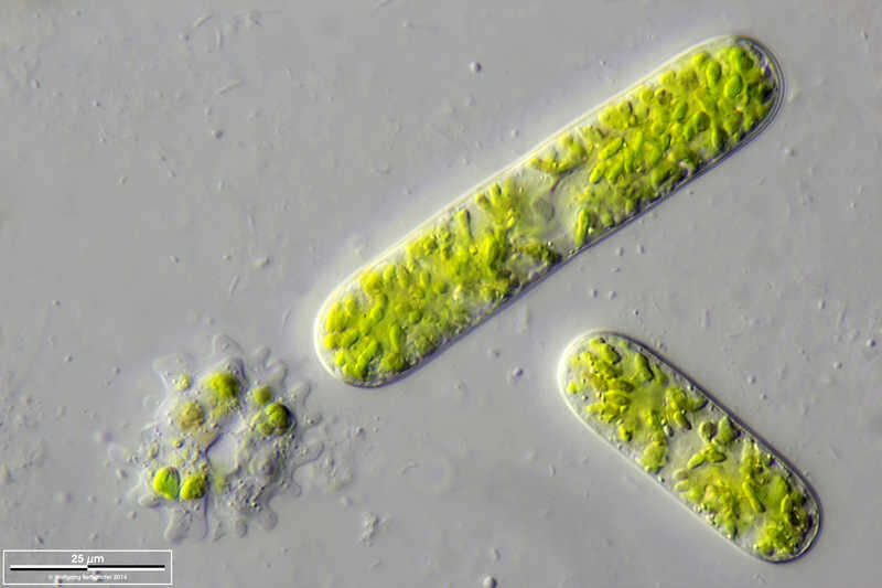
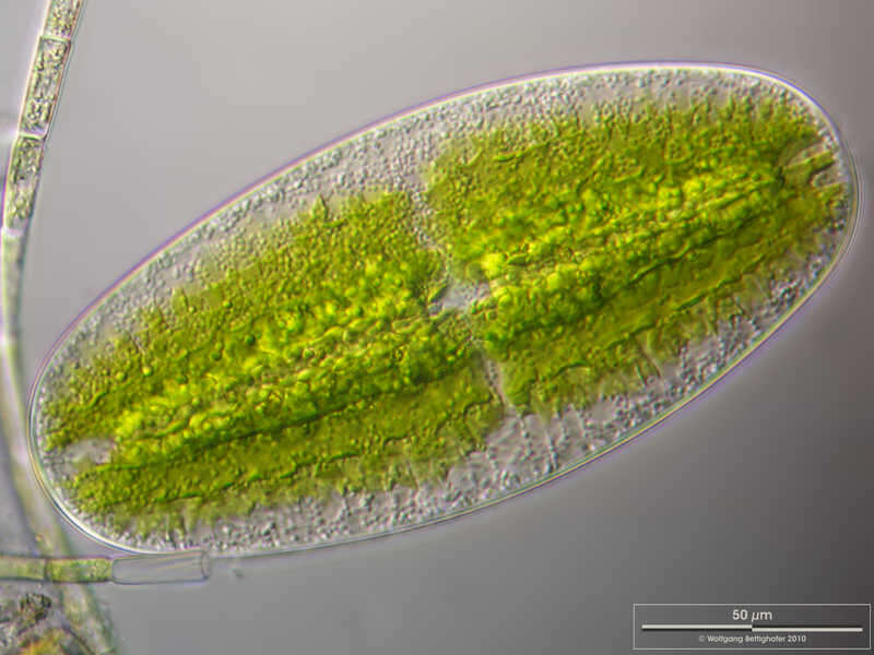
Netrium oblongum The image shows pyrenoids and the nucleus as pale and slightly structured disk in the center of the cell. In the pyrenoids, the cell produces the storage substance starch, which is deposited as a shell around them. Scale bar indicates 25 µm. Sample from wetland Lauchseemoor, Fieberbrunn, Tyrol, Austria. Sampling date 06/2023. The image was built up using several photomicrographic frames with manual stacking technique. Images were taken using Zeiss Axioplan with Olympus OM-D M5 MKII. Image under Creative Commons License V 3.0 (CC BY-NC-SA). Place name: Wetland Lauchseemoor, Fieberbrunn (Tyrol, Austria) Latitude: 47.46954439 Longitude: 12.53826499 Das Bild zeigt Pyrenoide und den Zellkern als blasse, leicht strukturierte Scheibe in der Mitte der Zelle. In den Pyrenoiden produziert die Zelle den Reservestoff Stärke, dieser wird als Hülle um diese abgeschieden. Multiebenen-Abbildung, manuell gestapelt. Der Messbalken markiert eine Länge von 25 µm. Probe aus dem Lauchseemoor bei Fieberbrunn, Tirol. Datum der Aufsammlung: 06/2023. Mikrotechnik: Zeiss Axioplan, Kamera: Olympus OM-D M5 MKII. Creative Commons License V 3.0 (CC BY-NC-SA). For permission to use of (high-resolution) images please contact postmaster@protisten.de.
-
Netrium oblongum Scale bar indicates 25µm. Sample from wetland Lauchseemoor, Fieberbrunn, Tyrol, Austria. Sampling date 06/2023. The image was built up using several photomicrographic frames with manual stacking technique. Images were taken using Zeiss Axioplan with Olympus OM-D M5 MKII. Image under Creative Commons License V 3.0 (CC BY-NC-SA). Place name: Wetland Lauchseemoor, Fieberbrunn (Tyrol, Austria) Latitude: 47.46954439 Longitude: 12.53826499 Multiebenen-Abbildung, manuell gestapelt. Der Messbalken markiert eine Länge von 25 µm. Probe aus dem Lauchseemoor bei Fieberbrunn, Tirol. Datum der Aufsammlung: 06/2023. Mikrotechnik: Zeiss Axioplan, Kamera: Olympus OM-D M5 MKII. Creative Commons License V 3.0 (CC BY-NC-SA). For permission to use of (high-resolution) images please contact postmaster@protisten.de.
-
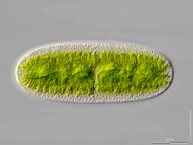
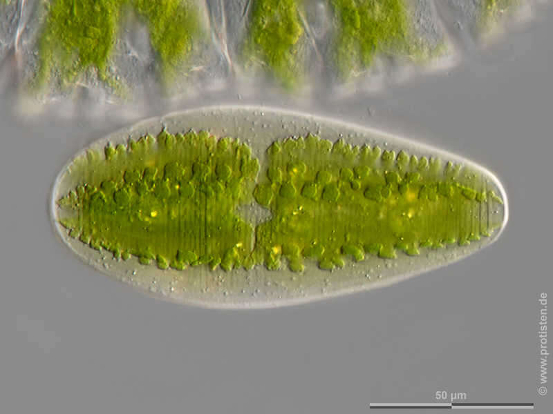
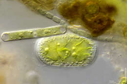
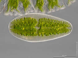
Netrium digitus var. latum The image exhibits an optical cross section through the middle of the cell, showing the complex shapes of the two chloroplasts, and the vesicular nucleus in the center of the cell. Scale bar indicates 50 µm. Sample from wetland Lauchseemoor, Fieberbrunn, Tyrol, Austria. Sampling date 06/2023. The image was built up using several photomicrographic frames with manual stacking technique. Images were taken using Zeiss Axioplan with Olympus OM-D M5 MKII. Image under Creative Commons License V 3.0 (CC BY-NC-SA). Place name: Wetland Lauchseemoor, Fieberbrunn (Tyrol, Austria) Latitude: 47.46954439 Longitude: 12.53826499 Das Bild zeigt einen optischen Querschnitt durch die Zellmitte mit den komplexen Formen der beiden Chloroplasten und den blasenförmigen Kern in der Zellmitte. Multiebenen-Abbildung, manuell gestapelt. Der Messbalken markiert eine Länge von 50 µm. Probe aus dem Lauchseemoor bei Fieberbrunn, Tirol. Datum der Aufsammlung: 06/2023. Mikrotechnik: Zeiss Axioplan, Kamera: Olympus OM-D M5 MKII. Creative Commons License V 3.0 (CC BY-NC-SA). For permission to use of (high-resolution) images please contact postmaster@protisten.de.
-
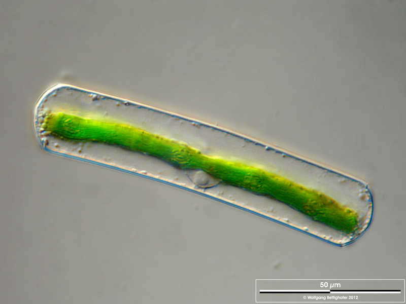
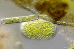
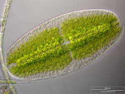
Netrium digitus var. latum Scale bar indicates 50 µm. Sample from a small wetland near Schladming (northern alpine region of Austria near Salzburg). Images were taken using Zeiss Universal with Olympus C7070 CCD camera.Image under Creative Commons License V 3.0 (CC BY-NC-SA). Place name: Wetland near Schladming (Austria) Latitude: 47.37386 Longitude: 13.823016 Der Messbalken markiert eine Länge von 50 µm. Probe aus einer Wiesenvernässung nahe Schladming/Österreich. Mikrotechnik: Zeiss Universal, Kamera: Olympus C7070. Creative Commons License V 3.0 (CC BY-NC-SA). For permission to use of (high-resolution) images please contact postmaster@protisten.de.
-
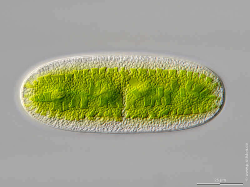
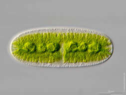
Netrium digitus var. latum The image shows the cell wall and the complex shapes of the two chloroplasts. Scale bar indicates 50 µm. Sample from wetland Lauchseemoor, Fieberbrunn, Tyrol, Austria. Sampling date 06/2023. The image was built up using several photomicrographic frames with manual stacking technique. Images were taken using Zeiss Axioplan with Olympus OM-D M5 MKII. Image under Creative Commons License V 3.0 (CC BY-NC-SA). Place name: Wetland Lauchseemoor, Fieberbrunn (Tyrol, Austria) Latitude: 47.46954439 Longitude: 12.53826499 Das Bild zeigt die Zellwand und die komplexen Formen der beiden Chloroplasten. Multiebenen-Abbildung, manuell gestapelt. Der Messbalken markiert eine Länge von 50 µm. Probe aus dem Lauchseemoor bei Fieberbrunn, Tirol. Datum der Aufsammlung: 06/2023. Mikrotechnik: Zeiss Axioplan, Kamera: Olympus OM-D M5 MKII. Creative Commons License V 3.0 (CC BY-NC-SA). For permission to use of (high-resolution) images please contact postmaster@protisten.de.
-
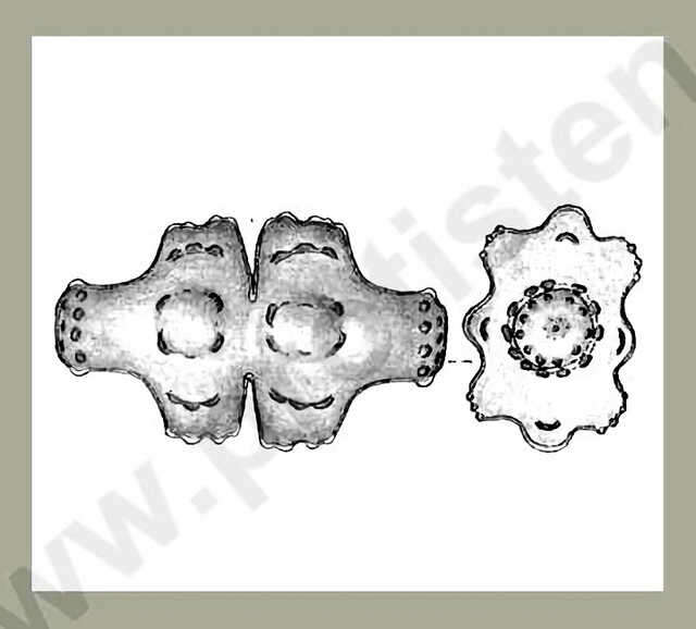
Euastrum attenuatum WOLLE var. splendens (F.E.FRITSCH & RICH.) GRÖNBLAD The cells are almost two times longer than wide. The cell halves have three lobes, the lateral lobes are broad and shallowly undulated at the ends. The vertex lobes are widened at the ends and are surrounded with a collar of warts. In the center of each cell half and on both sides of them there are broad swellings. The central cuts open outwards in an acute-angle. Dimension: Length 57 60 µm, width 33 35 µm.Ecology: In shallow, moderate acidic waters of fens and bogs.Occurrence: Southern America (Anden up to altitude of 3000 m toTierra del Fuego), Africa (Natal, Sudan), firstly recorded for Europe!Copyright by Prof. Rupert Lenzenweger, Ried im Innkreis, Austria. Place name: n. a. Latitude: 0 Longitude: 0 Die Zellen sind fast doppelt so lang wie breit, die Zellhälften sind dreifach gelappt, die Seitenlappen sind breit, an den Enden seicht gewellt. Die Scheitellappen sind an den Enden verbreitert, umgeben von einem Kranz breiter Warzen. In der Mitte der Zellhälften und beiderseits davon breite Anschwellungen. Die Mitteleinschnitte sind nach außen spitzwinkelig geöffnet. Dimensionen: Länge 57 60 µm, Breite 33 35 µm.Ökologie: In seichten, mäßig sauren Moorgewässern. Verbreitung: Südamerika (Anden bis 3000 m Seehöhe), Südamerika (Feuerland) Afrika (Natal, Sudan), Erstfund für Europa! Copyright by Prof. Rupert Lenzenweger, Ried im Innkreis, Österreich. For permission to use of (high-resolution) images please contact postmaster@protisten.de.
-
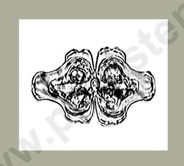
Euastrum attenuatum WOLLE var. splendens (F.E.FRITSCH & RICH.) GRÖNBLAD The cells are almost two times longer than wide. The cell halves have three lobes, the lateral lobes are broad and shallowly undulated at the ends. The vertex lobes are widened at the ends and are surrounded with a collar of warts. In the center of each cell half and on both sides of them there are broad swellings. The central cuts open outwards in an acute-angle. Dimension: Length 57 60 µm, width 33 35 µm.Ecology: In shallow, moderate acidic waters of fens and bogs.Occurrence: Southern America (Anden up to altitude of 3000 m toTierra del Fuego), Africa (Natal, Sudan), firstly recorded for Europe!Copyright by Prof. Rupert Lenzenweger, Ried im Innkreis, Austria. Place name: n. a. Latitude: 0 Longitude: 0 Die Zellen sind fast doppelt so lang wie breit, die Zellhälften sind dreifach gelappt, die Seitenlappen sind breit, an den Enden seicht gewellt. Die Scheitellappen sind an den Enden verbreitert, umgeben von einem Kranz breiter Warzen. In der Mitte der Zellhälften und beiderseits davon breite Anschwellungen. Die Mitteleinschnitte sind nach außen spitzwinkelig geöffnet. Dimensionen: Länge 57 60 µm, Breite 33 35 µm.Ökologie: In seichten, mäßig sauren Moorgewässern. Verbreitung: Südamerika (Anden bis 3000 m Seehöhe), Südamerika (Feuerland) Afrika (Natal, Sudan), Erstfund für Europa! Copyright by Prof. Rupert Lenzenweger, Ried im Innkreis, Österreich. For permission to use of (high-resolution) images please contact postmaster@protisten.de.
-
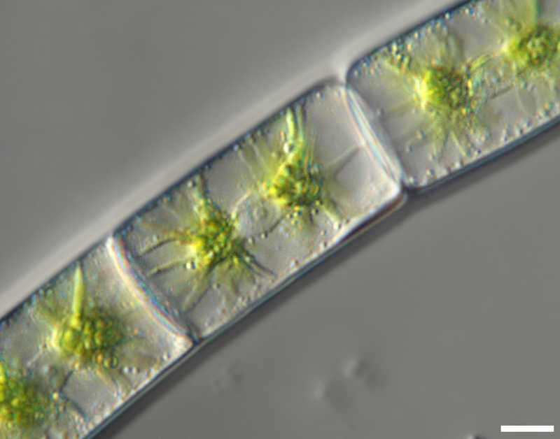
Zygnema spec. Zoom-in. You can see the two stellate chloroplasts and amidst, the nucleus with its central nucleolus. Scale bar indicates 25 µm.Sample from the pond Hegne Moor situated in the vicinity of Lake Constance. The image was built up using several photomicrographic frames with manual stacking technique. Images were taken using Zeiss Universal with Olympus C7070 CCD camera.Image under Creative Commons License V 3.0 (CC BY-NC-SA). Place name: Bog Hegne Moor near Lake Constance (Germany) Latitude: 47.718106 Longitude: 9.093974 Ausschnittsvergrößerung. Man sieht den Zellkern mit seinem zentralen Nukleolus, der zwischen den zwei sternförmigen Chloroplasten liegt. Multiebenen-Abbildung, manuell gestapelt. Der Messbalken markiert eine Länge von 25 µm. Probe aus dem Simmelried nahe Konstanz. Mikrotechnik: Zeiss Universal, Kamera: Olympus C7070. Creative Commons License V 3.0 (CC BY-NC-SA). For permission to use of (high-resolution) images please contact postmaster@protisten.de.