Pinus tropicalis range map
Опис:
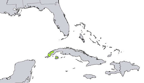
Description: Range map of Pinus tropicalis'. Date: 1999. Source: Digital representation of "Atlas of United States Trees" by Elbert L. Little, Jr. http://esp.cr.usgs.gov/data/atlas/little/. Author: U.S. Geological Survey. Permission(Reusing this file): Public domainPublic domainfalsefalse. : This image is in the public domain in the United States because it only contains materials that originally came from the United States Geological Survey, an agency of the United States Department of the Interior. For more information, see the official USGS copyright policy. Bahasa Indonesia ∙ català ∙ čeština ∙ Deutsch ∙ eesti ∙ English ∙ español ∙ français ∙ galego ∙ italiano ∙ Nederlands ∙ português ∙ polski ∙ sicilianu ∙ suomi ∙ Tiếng Việt ∙ Türkçe ∙ български ∙ македонски ∙ русский ∙ മലയാളം ∙ 한국어 ∙ 日本語 ∙ 中文 ∙ 中文(简体) ∙ 中文(繁體) ∙ العربية ∙ فارسی ∙ +/− :.
Се јавува на следниве страници:
- Life
- Cellular
- Eukaryota (еукариот)
- Archaeplastida
- Chloroplastida
- Streptophyta
- Embryophytes
- Tracheophyta
- Spermatophytes (семени растенија)
- Gymnosperms
- Pinopsida
- Pinales (Боровидни)
- Pinaceae (Борови)
- Pinus (Бор)
- Pinus tropicalis
Сликата ја нема во ниедна збирка.
Информации за изворот
- лиценца
- cc-publicdomain
- создавач
- U.S. Geological Survey
- извор
- Digital representation of "Atlas of United States Trees" by Elbert L. Little, Jr. http://esp.cr.usgs.gov/data/atlas/little/
- изворно
- изворна податотека
- посети извор
- соработничко мреж. место
- Wikimedia Commons
- ID