Bear grass - Xerophyllum tenax - Flickr - brewbooks
Description:
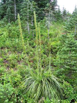
Description: Xerophyllum tenax Bear grass Lakes Trail, Mount Rainier National Park Elevation 1510 meters (4950 feet) Hiking and botanize in Reflection Lakes and Paradise area of Mount Rainier as part of MeadoWatch. Date: 28 August 2014, 14:29. Source: Bear grass - Xerophyllum tenax. Author: brewbooks from near Seattle, USA. Camera location 46° 46′ 19.61″ N, 121° 43′ 25.28″ W : View all coordinates using: OpenStreetMap - Google Earth: 46.772115; -121.723688.
Included On The Following Pages:
- Life (creatures)
- Cellular (cellular organisms)
- Eukaryota (eukaryotes)
- Archaeplastida (plants)
- Chloroplastida (green plants)
- Streptophyta
- Embryophytes
- Tracheophyta (ferns)
- Spermatophytes (seed plants)
- Angiosperms (Dicotyledons)
- Monocots (Monocotyledons)
- Liliales
- Melanthiaceae (bunch flower family)
- Xerophyllum
- Xerophyllum tenax (Basket-grass)
This image is not featured in any collections.
Source Information
- license
- cc-by-sa-3.0
- copyright
- brewbooks
- creator
- brewbooks
- source
- Flickr user ID brewbooks
- original
- original media file
- visit source
- partner site
- Wikimedia Commons
- ID